The Coastal Commission recently awarded a Whale Tail Grant to the CA Urban Streams Alliance – The Stream Team. The grant is to initiate a stewardship engagement and watershed monitoring effort for the impaired, lower reach of the Gualala River and estuary, a habitat for endangered species such as young Coho salmon and steelhead.
Redwood Coast Land Conservancy (RCLC) and Friends of the Gualala River (FOGR) are partnering with The Stream Team in this volunteer, community-based project. The project is inclusive, aiming to recruit and involve a broad spectrum of Mendonoma residents from Manchester to Stewarts Point including students, teachers, and members of community organizations.
Although The Stream Team is based in Chico, California, Timmarie Hamill, the Director of The Stream Team, is not new to coast. Her involvement began in 2000, when she landed a grant with Friends of the Garcia River (FrOG) to engage students and community members in conducting water quality surveys of the Garcia River. In 2003, Timmarie completed her teaching credential while working at Point Arena High School and Pacific Community Charter School as a student teacher of biology. For Discover the Coast in 2016 and 2017, The Stream Team provided a docent station to test the water quality of a creek on Point Arena–Stornetta Public Lands.
The Gualala River Stream Team Stewardship Project has four main goals: (1) Raise awareness about the Gualala River and its estuary by promoting education and engagement through environmental stewardship; (2) Establish a Gualala River Stream Team to engage the community in watershed assessment; (3) Involve a wide range of Mendonoma residents; and (4) Build organizational capacity to sustain the projects.
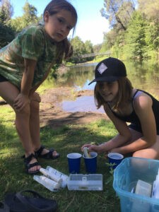
The Stream Team’s annual training and quarterly water monitoring events took place on RCLC’s Mill Bend Property. At the annual training in July, participants learned about: 1) habitat and water quality impairments within the Gualala River watershed, 2) life cycle of Coho salmon and steelhead, 3) effects of climate change on watershed health, 4) effective stewardship practices, 5) proper use of monitoring equipment and sampling protocols, and 6) safety measures for field work.
Quarterly water monitoring events will evaluate chemical, physical, and biological characteristics of the Gualala River and its estuary. FOGR is providing funding for The Stream Team’s preparation of the Monitoring Plan (MP) and Quality Assurance Project Plan (QAPP). The next event is scheduled for Saturday October 22, 2022.
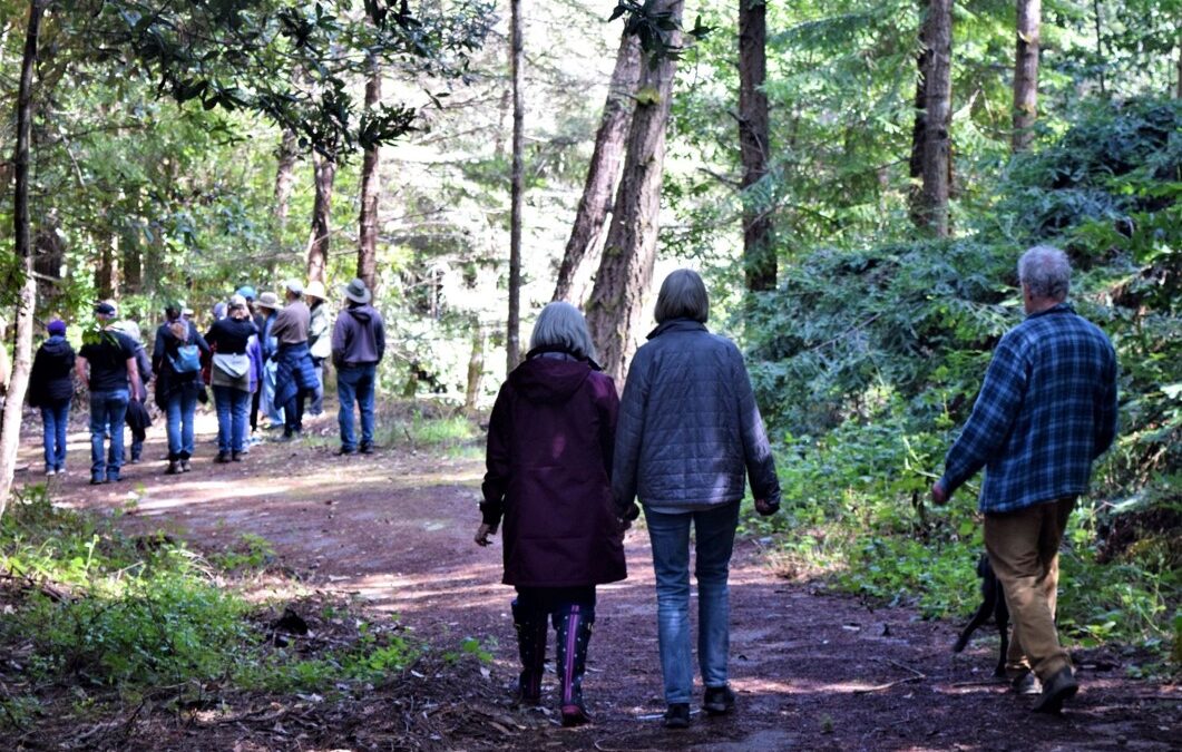
Redwood Coast Land Conservancy had an open house on Sunday April 24 as part of Earth Day Weekend, inviting the community to visit the Upper Mill Bend Conservation area.
We led guided walking tours, and were happy to be able to show our new revitalized hiking trails, the extensive clearing of invasives, the history of the Mill and Pioneer Cemetery, and our plans for expanding public access with a focus on habitat rehabilitation.
As part of the event we were joined by The Stream Team to demonstrate their plans for engaging community volunteers in monitoring our river’s water quality while promoting awareness and education about the health of the Gualala River and its estuary.
Our event was also a great chance to interact with several of our conservation partners, including Friends of Gualala River, Mendocino Coast Audubon, the Dorothy King Young chapter of the California Native Plant Society, Sea Ranch Coastal Stewardship Task Force and the Gualala Climate Action group.
We would like to thank all the visitors for their enthusiasm and interest. Mill Bend’s 113-acre preserve is a jewel that serves as the gateway to Mendocino County and our local community involvement is a game-changer.
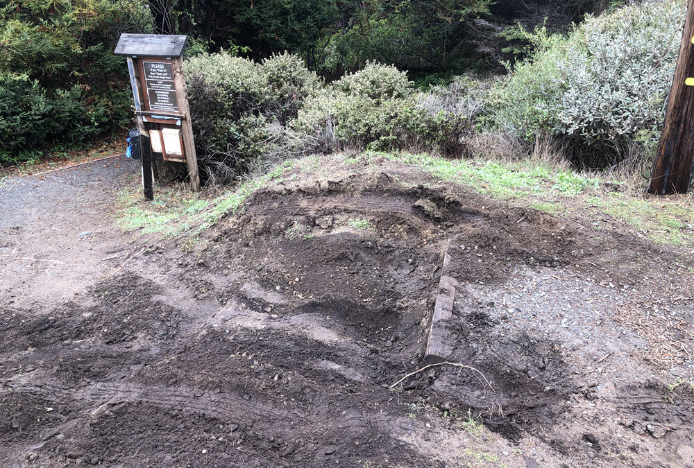
Above Photo: The access steps to Cooks Beach taken this weekend after the steps and nearby berm were damaged by an unknown motorist.
Published by the Independent Coast Observer, October 29, 2021
Photos by Joel Chaban
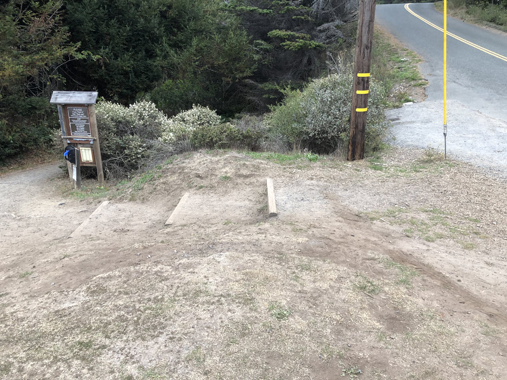
The access steps to Cooks Beach before damage by an unknown vehicle driving up and down tore them up. The photo was taken as part of an application to the California Coastal Commission to install bollards protecting the bluff top.
The recent storm is not the only thing causing damage to local beaches. According to Joel Chaban, secretary of Redwood Coast Land Conservancy, it appears a pickup truck drove up and down the bluff top steps used as an entrance to Cooks Beach in the last few days, causing damage to the steps.
In addition, the driver drove up and down the berm adjacent to these stairs, Chaban said.
“This berm, previously eroded by a wedding party event a couple of months ago, now has several long deep gouges on the ocean side of the berm that run in several directions,” he explained.
“The earth has also been gouged along both sides of the stairs and on the stairs where it appears the tires were spinning in an attempt to drive up the stairs.”
The wedding Chaban described was done without permission from RCLC, Mendocino County or the California Coastal Commission, and had already caused erosion to the berm before the recent vehicle damage.
Currently there is no plan to do any repairs at Cooks beach, said Chaban, who is the project manager for that beach. “I will try to get down there and do some repairs on the stairs and put down some wood chips to protect them from foot traffic,” he said, adding that RCLC is in the process of applying for Coastal Commission and County permits to put up bollards to prevent any driving on the bluff top.
However, it will take several months to get the permits, he said.
“I ironically took the ‘before’ photos a week be fore the latest damage to develop design drawings for the bollards required by the County and Coastal Commission,” Chaban added. “In the meantime, the ground is wet and will get wetter! Be thoughtful and careful.”
Cooks Beach, just north of Gualala, is one of four properties in Mendonoma stewarded by RCLC. The others include the Gualala Bluff Trail, Hearn Gulch and Mill Bend.
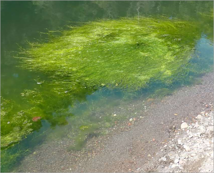
Read about the effects of drought changes in the Gualala River estuary’s summer lagoon. Are you seeing native aquatic vegetation or algal blooms? Dr. Peter Baye of Friends of Gualala River takes us on a virtual field trip to answer this question and more.
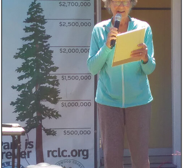
It takes more than tax-deductible donations and grant funding to realize the ambitious projects of the Redwood Coast Land Conservancy. On Saturday, the 30-year-old grass-roots conservation organization honored more than 75 hands-on volunteers at an event at its newest acquisition, the 113-acre Mill Bend property on the Gualala River.
President Tina Batt said many of the volunteers show up day after day and week after week to clear trails, remove invasive pampas grass, and maintain all the group’s coastal access projects, including the Gualala Bluff Trail, Cook’s Beach access trail, and Hearn Gulch.
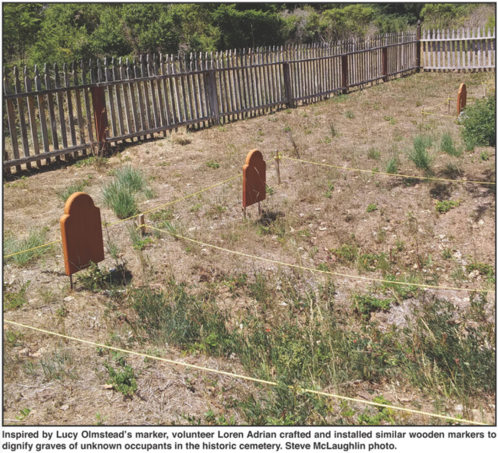
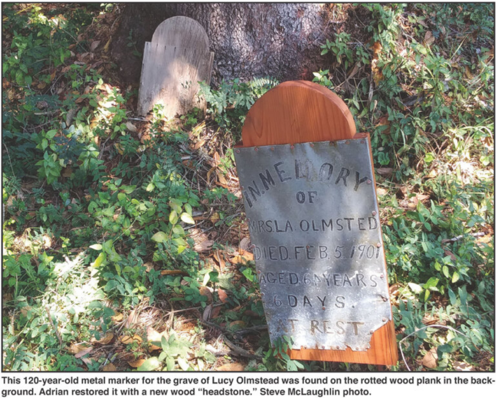
After months of work by dedicated volunteers, with funds donated by those same volunteers, the cemetery has been cleared of overgrowth; headstones and markers have been restored, and signs have been placed throughout the cemetery with researched information about the lives of the people buried there. A rebuilt fence and restored sign defines the cemetery.
One of the most dramatic achievements so far has been the restoration of the historic Gualala Cemetery on the Mill Bend property, which was nearly invisible a year ago because of the tangled jungle of brush and overgrown trees.
After months of work by dedicated volunteers, with funds donated by those same volunteers, the cemetery has been cleared of overgrowth; headstones and markers have been restored, and signs have been placed throughout the cemetery with researched information about the lives of the people buried there. A rebuilt fence and restored sign defines the cemetery.
Batt told the ICO that the cemetery has had more people “visiting for the right reasons,” that is, respectful historical interest.
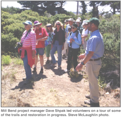
During tours of the Mill Bend site, project manager Dave Shpak explained some of the environmental choices the organization must consider as it undertakes restoration and plan access improvements.
More information on RCLC and its projects is available at www.rclc.org.